
This invitation was sent by the Mayor of Derby, Councillor J. H. Christmas J.P. to Mr and Mrs Paget then residing at 124 Weston Road, Aston-on-Trent Derby to attend the unveiling of a plaque at the Liversage Arms. Mr Samson Selig, who also supplied the plaque, was an eminent New York lawyer and enthusiastic collector of old Derby china. He had been inspired and motivated by a comment in F Brayshaw Gilhespy’s book entitled Crown Derby Porcelain which had been published 5 years earlier. In his book Gilhespy bemoans the loss of the factory:
“A low building with an archway facing on to the Nottingham Road is now our only link with the past, all the factory buildings having disappeared these many years since. If Derby people are not interested in their own history, plenty of visitors from home or overseas would be gratified by the view of a plaque with a commemorative description on the site.”
The Pagets also received a separate invitation from Royal Crown Derby to attend the Dinner held in honour of Mr Selig.

The event was recorded in the Derby Evening Telegraph Saturday September 29th 1956 edition under the headline “Plaque Marks 200 Years of Crown Derby - New Yorker’s tribute to William Duesbury”. The plaque is reported to declare:
“On this site in 1756, William Duesbury I established a factory to continue the manufacture of china commenced in Derby in 1750. From here the Crown Derby tradition of fine quality and craftmanship has become famous the world over.”
The plaque was apparently “unveiled on the side of the public house, in a side street where the ceremony could be conveniently held without interfering with the traffic. Later it is to be moved to the front of the building.”
At the Dinner held later that day, Phillip Robinson, proposing the health of Mr Selig, “thanked the Mayor and Corporation for the loan of the civic banqueting china” (which had been given to the Corporation by the Derby Evening Telegraph - see examples on the U K Commissions and Second World War Memorabilia page). He is quoted as saying that “Crown Derby now had more friends and more accounts in new countries than they had before the war. They had experienced serious problems and it might interest historians to know that in 1941, (the) Crown Derby works nearly closed.” (See blog page 1939-45). The extent of the difficulties facing the works in 1941 can only now be determined by further research, but it does seem likely that the business would have been in dire straits if it had not been for the export trade, which was principally to the US at that time.
Mr Selig was presented with a pair of china birds.
Phillip Robinson very nearly didn’t make it to the unveiling of the plaque or dinner, as his wife Dorothy was very unwell. He was given assurances by the consultant that he would be summoned if her conditioned worsened. Samson Selig became aware of Phillip Robinson’s dilemma, and as a sign of his appreciation, he presented to the Robinson family a touching gift of a silver christening cup to mark the recent birth of the author of this blog.

Christening cup by Mappin and Webb, hallmarked Sheffield 1956
At some point the plaque vanished. We know that it was in situ on the “grime stained” front wall of the pub, because this is confirmed in an article by Derby Evening Telegraph reporter Anthony Inchley entitled “Do-it-yourself landlord gives Liversage Arms a face-lift” which appeared on the 17th November 1961. The Landlord, Gerry Kerney, had by then been publican at the Liversage Arms for some 2 1/2 years. Amongst his many reported makeover innovations, was an oil painting in the Lounge which at the touch of a switch “swings open to reveal a dartboard.” Ahead of his time, do-it-yourself was a novel and unusual activity, hence the press article.
The Liversage Arms owned by the Liversage Trust forms part of its Nottingham Road estate. It was built in 1896 “to designs by Alexander Macpherson, one of Derby’s most important architects.”
When St Alkmunds Way was opened in 1969, the setting and location of the Liversage Arms was totally transformed. The building was left very close to an elevated section of a busy dual carriageway. This isolated it from the passing trade it would have enjoyed when it directly fronted the main Nottingham Road.

Beer Mat - date unknown but probably C1978 when Andy Morrow is reported to have been serving pints of Pedigree at the Liversage Arms during the Derby City Charter Beer festival.
Reports on the Pub suggest that it re-opened in 2005 before closing in 2007. In 2009 it re-opened as “AJ’s”, perhaps with the same licencees, to trade until at least 2011. By 2013 it appears that the building was no longer a viable proposition for a public house, but located within the Nottingham Road Conservation Area created in 1993, demolition was not an option. Planning Permission was granted to the Trust in 2014 for conversion of the property into 6 flats. It seems, from the Planning Statement, that the property had by then “stood empty for quite some time.” The drawbacks of the location were plausibly outlined:
“Passing fairly close to the front of the building and at an elevated level is St. Alkmund's Way forming part of the Derby inner ring road. The proximity of the road has consequences as far as the redevelopment is concerned, both from an air quality and noise disturbance point of view.”
No mention was made of the plaque in the Planning Application, and by this time it seems to have disappeared.


The pictures above show the Liversage Arms as it appears today having been converted into flats. The second image [on the right] shows the decorative terracotta panel above the front entrance door facing Nottingham Road. Images © John Robinson
In 2013 Derby City Council and Derby Civic Society announced they they would erect a Blue Plaque as a memorial to Duesbury at Landau Forte college, in Derby.
Image © John Robinson
The wording on this new plaque is clearly not the same. A press release made the following claims:
“William Duesbury (1725 – 1786), the famous Georgian porcelain factory owner who co-founded Royal Crown Derby, has been honoured with a Blue Plaque today (Friday 18 October 2013) at the site of his former factory on Fox Street – now Landau Forte College – and an unveiling of some of the china he made during his lifetime.
Duesbury, who established the Derby Porcelain factory on Fox Street in about 1750 and went on to gain international renown for high quality porcelain china with potter and jeweller Andrew Planche, has been recognised with the official unveiling of the Blue Plaque by the Mayor of Derby, Councillor Fareed Hussain, the CEO of Royal Crown Derby, Kevin Oakes, the Chair of Governors at Landau Forte College, Keith Doble, and the Chair of Derby Civic Society, David Ling.“
In a press release David Ling says:
“William Duesbury is a worthy recipient of a Derby Blue Plaque; he was an important enameller, a British entrepreneur, and founder of Royal Crown Derby. Duesbury arrived in Derby with his father on January 1st 1756 having acquired a share in the Derby Potworks on Cockpit Hill. In 1773 Duesbury’s hard work was rewarded by King George III who, after visiting the Derby works, granted him permission to incorporate the royal crown into the Derby back stamp after which the company was known as Royal Crown Derby. Duesbury died of a heart attack in 1786 at the age of 61, and is buried in St Alkmund’s Church, Derby. We are all looking forward to the unveiling of this very special Blue Plaque at Landau Forte College on the site of Duesbury’s factory.”
There are some obvious factual inaccuracies in the statements. I can find no record of Fox Street ever being the site of the factory, only Nottingham Road. When Duesbury was given a patent by George III in 1773 to stamp his ware with a crown, Derby China became “Crown Derby” not “Royal Crown Derby.” The Nottingham Road business passed from William Duesbury I to his son William Duesbury II in 1786 and thence to various owners including Robert Bloor, until 1848 when it was forced to close down. Some of the workers and artists then managed to raise enough funds to “procure the best of the moulds, body formulae, patterns books, etc. from the old factory, and obtain the right to continue the production of Derby China, including that of using various marks. They established a new factory at King Street, Derby.”
The King Street Works. Image Courtesy of the Derby Telegraph. Planning permission has recently been granted for conversion into shops and six homes. See https://www.derbytelegraph.co.uk/news/derby-news/eyesore-city-centre-building-turned-3640821 dated 13th December 2019
Whilst the King Street based business was up and running from 1848, an entirely separate business - the Derby Crown Porcelain Company - based at Osmaston Road commenced china production in 1876. This business separately secured the royal warrant becoming Royal Crown Derby in 1890. In 1935, Royal Crown Derby took over the King Street based business. In view of his past track record although not listed as a director at the time it seems inconceivable that Harold Taylor Robinson did not have a hand in the takeover. The King Street operation was closed down, allowing the Osmaston Road business to claim the Duesbury connection.
The apparent anomalies with regard to the location of the Duesbury factory prompted me to research maps and other resources which are available online. I also made enquiries of the Liversage Trust which has records in respect of their Nottingham Road estate dating back to 1518. The circumstances surrounding the development of the factory are the subject of some debate, but the following dates do appear to be generally accepted:-
1756 - Date of association of William Duesbury, John Heath and Andre Planche and the year of the acquisition of cottages on Nottingham Road opposite St Mary’s Bridge.
1773 - Visit of George III to the factory.
1786 - Death of William Duesbury I.
1795 - William Duesbury II takes into partnership Michael Kean.
1796 - Completion of the canal and death of William Duesbury II.
1797 - Erection of a new factory by Michael Kean.
1809 - Purchase of the business by Robert Bloor.
1828 - Retirement from the business by Robert Bloor. Business managed by James Thomason
1844 - Thomas Clarke takes over the business.
1845 - Demolition of original factory buildings and erection of a nunnery on the site.
1848 - Re-establishment of the business at King Street.
1863 - Demolition of the nunnery.
1896 - Construction of the Liversage Arms.
I have found only two images of the works thus far:-

Old China Works Derby showing kilns for firing the porcelain. John Keys, Sketches of Old Derby and Neighbourhood (London and Derby 1895)
Image courtesy of Local Studies and History - Birmingham Central Library
Although this image is reputed to show the Derby works, Peter Lead has kindly pointed out that the same image appears on page 401 in the first volume of Jewitt's Ceramic Art of Great Britain (1878). Peter goes on to say that “you will notice that this shows the Bristol works and is based on four large tiles, dated 15th May 1820. It appears that it was Samuel Keys who said it was the Derby works”. It therefore appears that John Keys appropriated this image and falsely attributed it to the Derby works. It gives an impression of the activities carried out at the time and the type of premises used only.
This image of the Duesbury works dated C1780’s appears in Bow, Chelsea and Derby Porcelain by William Bemrose 1898.
Bemrose informs us that this image was “drawn from memory by Moses Webster in 1870 and approved by several of the old china painters who recollected the old works”. As the factory had been demolished twenty five years earlier in my view it can really only be regarded as a representation or artist’s impression of the works, not an accurate record of the buildings. It shows an assortment of buildings arranged in a rectangle around a central yard area, with the bottle kilns and chimneys inside the complex and to the right. The three story building on the left provided accommodation for the owner or manager, as the process would have needed 24 hour supervision. This has its own pedestrian gate and path for access. The factory is accessed through an archway with two separate doors for the use of the workforce. With the prevailing wind in the UK being from the south west, it would have been sensible to site the living accommodation upwind of the bottle kilns!
This floor plan appears in Bemrose and was apparently copied from a lease to Bloor dated 1815. There are a number of issues with it. Firstly it shows only the ground floor layout, and the image of the factory shows two, three and possibly four storey buildings. The bottle kilns or “cones” are only two and not four in number and are in different locations. There is no scale shown and it is “copied” from the lease, so there is no way of determining its accuracy without having sight of the original. However there are three points of particular interest, the stated dimension of 170ft for the frontage, the location of the bird cage walk and the reference to the adjoining premises “Mr Craynes property”.
In order to try to identify the site of the factory I have looked at the various maps which are available. These findings are set out below.
Part of the The 1791, George Moneypenny map of Derby. Reproduced courtesy of the Derby Local Studies Library. This map is believed to be a reprint of a map originally produced by Peter Perez Burdett dated 1767 and engraved by Thomas Kitchin of London.
Number 7 refers to the China Works, which are clearly shown fronting Nottingham Road. In his book “Crown Derby Porcelain” by F Brayshaw Gilhespy, the origins of the factory are described as follows:
“Early in 1756 houses were purchased by William Duesbury and John Heath, on the Nottingham Road, by St Mary’s Bridge. On this site the Derby Porcelain Factory was built”.
In Bow, Chelsea and Derby Porcelain William Bemrose quotes local historian William Hutton writing in 1791 as follows:
“The spot upon which this elegant building stands, which is internally replete with taste and utility, was once the freehold of my family. It cost thirty-five pounds, but the purchaser, my grandfather’s brother, being unable to raise more than twenty-eight, mortgaged it for seven. Infirmity, age and poverty obliged him to neglect the interest, when in 1743 it fell into the hands of my father, as heir-at-law, who, being neither able nor anxious to redeem it, conveyed away his right to the mortgage for a guinea.”
William Bemrose also refers to “Extracts from Mr Duesbury’s Deeds” and to a series of conveyances dated 1 August 1780 whereby 2 tenaments, 5 other tenaments and a dwelling house situated “East of St Mary’s Bridge” which had been converted into workshops “for the making of china” were conveyed to W Duesbury following the bankruptcy of John Heath.
Without access to the original documents and any title plans it is unclear as to exactly what basis the properties were owned - i.e. long leasehold or freehold, and as to what constituted the boundaries of the original works. However, William Hutton clearly refers to a “freehold” interest which would suggest that in fact the tenaments and house were outside of the area owned by the Liversage Trust. The maps show no dividing boundary between the China Works and the five smaller buildings north west of the main part, which extend as far as St Mary’s Bridge. Are these properties the ones acquired by William Duesbury and John Heath?
The business soon outgrew the original site and on the 29th August 1764, the Liversage Trust granted a 21 year lease to John Heath of “3a commonly called Calver Close parish of St Alkmund’s” at a rent of £9 10s p.a. The main building shown above was built on this land. The footprint of the main part of the works does seem to fit the image in William Bemrose’s book - i.e. a rectangular layout with a gap in the buildings to the front left corner. The date of the map (1767- reprinted 1791) also tallies with the date of the Liversage Trust lease and the wording under the illustration “at the close of the first Duesbury period” i.e. 1786. The Silk Mill and St Mary’s bridge remain as useful fixed points throughout the maps to follow.
This image is taken from E W Bradley’s plan of Derby published to accompany “the Beauties of England and Wales” in 1806. The canal had been completed in 1796, the navigable part extending only as far as the factory and not beyond the junction of Nottingham Road and Ford Lane. Canals were expensive to construct; the canal company derived its revenue from the transport of materials and there would have been no point at that time in extending it beyond the factory.
The arrival of the canal would have been very beneficial to the business as it ensured a regular supply of coal and other raw materials. The inscription “China Works” extends beyond the main part of the works, and the buildings to the south east (which have been badly coloured in reverse - the red square in the main building is almost certainly a courtyard) may represent additions to the main part of the works. However the arrival of the canal would have attracted other concerns, and we know from the records that on the 6th of April 1772 the Trust granted a 21 year lease to “Worthy Balme of Derby, ropemaker, of close 2a in the parish of St Alkmund’s near the road leading from Derby to Chaddesden, rent £8 5s p.a.”. The long thin building to the east of the site could well have been used as a rope works. This image is taken from a reproduction of the map in my own collection.
This image is taken from the Swanwick map of Derby 1818.
According to Gilhespy:
“In 1797 Michael Kean erected a new factory adjoining the original one; his purpose being to manufacture earthenware. This venture was a failure and the new factory in 1799 started to manufacture porcelain, absorbing the workmen from the older portion of the factory which was closed for some years but partly reopened in the earlier years of the next century: a bird cage walk connected the two buildings”.
The second phase of the factory is shown in the above image verged blue, Michael Kean’s factory site is verged red, and the bird cage walk (jitty I suspect!) linking the two factories is marked with an arrow and coloured brown.
It appears that on the Death of William Duesbury II in 1796 part of the land which had been leased to the works by the Trust entitled “Mr Duesbury’s close, garden and woodyard” amounting to some 2.51 acres, was surrendered to the Trust and divided into plots. This area extended from the east of the works as far as present day Clarke Street and is shown in the map extract above. The Trust records confirm that on the 30th March 1797 Michael Kean was granted a 60 year lease “of a parcel of ground of 3840 sq yds. part of Calver Close, rent £16 p.a. to build buildings on the site to bring the annual value up to £20 p.a. during the first three years of the term”. Michael Kean must have expedited the construction works, because by the 3rd November the same year he took a new 90 year lease on the same site “now with other buildings” at the increased rent of £20 p.a. The site was still not large enough and on the 22nd of June 1801 the Trust agreed an assignment of the adjacent plot of some 2570 sq yds from John Coke to Richard Kean “for the residue of the term” i.e.until 29th March 1857.
In 1809 Robert Bloor purchased the business from Kean.
Cup and Saucer by Robert Bloor. If you would like to see more examples of early Derby porcelain you will find an extensive collection on this website https://www.derbyporcelain.org.uk
The buildings fronting the Nottingham Road to the north west are presumably the original houses which by this time may or may not form part of the works.
Early on in its life the canal had been extended beyond the works, with the construction of a lock - The Phoenix lock - to link the canal to the river, thereby providing access to Darley Abbey Mills. This extension to the canal is shown above, together with the enlarged basin. By this time buildings had been constructed on Ford Lane. There is no sign of Fox Street. Twenty two years later the railway arrived and this proved to be very bad news for the canal company!
Convent on site of original factory on Nottingham Road 1852. Image courtesy of Ordnance Survey
This image is taken from two adjoining Ordnance Survey maps of 1852. According to Gilhespy:
“in 1845 a nunnery was built on the site of the original factory but this was demolished in 1863 as the site was so unhealthy”.
The Liversage Trust records differ slightly quoting the history as follows:
“Following Robert Bloor’s death in March 1846, on 28th November the unexpired lease of the whole property on the Nottingham Road….were first advertised “To be Sold or Let” in the Staffordshire Advertiser. This advertisement was repeated on 3rd July 1847 […] Then on 31st July 1847 the announcement stated that the proprietors are open to receive proposals for PARTNERSHIPS for any respectable party willing to enter into the concern”.
Evidently none were forthcoming and in an advertisement in the Derby Mercury dated 23rd May 1848 it was stated that the manufacture will be discontinued. This was followed by a further announcement dated 14th February 1849, stating that: “The Business of this establishment having been disposed of to Messrs Boyle and Sons, Fenton” and the property was conveyed in in March 1847 to two Roman Catholic priests for £1,950 and the buildings were demolished. It is interesting to note that if this second account is factually correct and the business was sold to Boyle and Sons, this does somewhat undermine subsequent claims to be the successors of Duesbury.
There is clearly a discrepancy regarding the dates, but in essence by 1852 the factory built by Kean has disappeared. The factory as shown in William Bemrose’s image has been redeveloped, and the bird cage walk linking the two factories which was located to the rear of 51 and 53 Nottingham Road apparently built over.
The Convent building is clearly shown, and it seems that additional land to the rear was used as a garden. Note that the Convent garden extends only so far to the east, and the site sold did not include 51 and 53 Nottingham Road. Although not marked, Wood Street is now in evidence, but not Alice Street or indeed Fox Street. The arrival of the railway had not yet impacted the area.
This image of The Convent of St. Joseph appears in Bow Chelsea and Derby Porcelain by William Bemrose.. Apparently designed by renown architect Augustus Pugin for the Sisters of Mercy from Kinsale and built at a cost of £10000, “the situation was found to be so unhealthy that in the year 1863 the convent was pulled down and the materials sold”. The image shows the position of the site relative to the the bridge over the canal and includes the Phoenix lock.. It is also interesting to note that all the gables front onto Nottingham Road.
Ordnance Survey map 1882. The image is Reproduced with the permission of the National Library of Scotland.
By 1882 the area had undergone a dramatic change as a result of the railway. Dominated by heavy industry, the short lived Convent building has been replaced with malthouses which also take up the greater part of the area including the Landau Forte site. The Britannia works was making steel girders for bridges, hardly conducive for quiet contemplation and prayer! By now Wood Street, Fox Street and Robert Street appear on the map, but not Alice Street, because the Liversage Arms was not built until fourteen years later in 1896. The fortunes of the canal were severely affected by the railway:
“Receipts fell from £8,180 to £2,556 between 1838 and 1868, and dividends for the same period fell from 10.5 per cent to 4 per cent. An attempt was made in 1872 to sell the whole canal to the Midland Railway for £90,000, without success, and a similar offer to the London and North Western Railway also failed” (Wikipedia, accessed 01/05/2020).`
Ordnance Survey map 1899
This map also shows the redevelopment carried out by the Liversage Trust. It is the first time that the Liversage Arms Pub appears, built three years earlier. It seems that most of the area west and east of Robert Street was cleared in 1896 to include some properties on the west side of Alice Street, but not those fronting Fox Street or Clarke Street. Perhaps these were held on a long lease and therefore outside the control of the Trust. Apparently the initial estate built by the Trust “which occupied the site for at least a century prior to that, but was in a poor state of repair .. was demolished on the recommendations of the Birmingham surveyor, J Mathews.” You can see the outlines of these buildings, which were probably “back to back” houses, in the 1852 and 1882 map extracts above.
It should be appreciated that kiln remnants were known to be incorporated in the foundations of the Liversage Arms, being visible in the basement.
The Peacock Inn and numbers 91 and 109 Nottingham Road, all stone built, survived. Numbers 51 and 53 Nottingham Road, cottages immediately to the west of the Liversage Arms site were in separate ownership and were spared, and remain today. The letters PH in front of the thin oblong building to the west of the Liversage Arms - 53 Nottingham Road, relate to the past use of that building as a public house apparently known as The Punch Bowl.
Ordnance Survey Map revised in 1938 but published in 1947. Reproduced with the permission of the National Library of Scotland.
This image is taken from an ordnance survey map revised in 1938 but not actually published until 1947, after the war. The red arrow shows the location of the Liversage Arms site. The decline of the canal is now evident with the basin reducing in size:
“Traffic (had) suffered further decline when Butterley Tunnel on the neighbouring Cromford Canal had to be closed. The Little Eaton gangway was closed in 1908, ten years after the action was first considered, and the Little Eaton branch followed on 4 July 1935, when the company obtained a warrant for its closure. Attempts to close the Sandiacre line in 1937 were thwarted by objections from Imperial Chemical Industries. Commercial traffic on the remainder of the canal ceased in 1945. In 1964 the canal company gained permission to close the rest of the canal”. (Wikipedia accessed 01/05/2020)
Precisely where was the Duesbury factory site? One important clue lies in the description contained within the Nottingham Road Conservation document (Revision No. 2 December 2003) as published by Derby City Council. This states that:
“Close by the (Liversage) estate was the original site of the Derby Porcelain Works (now Royal Crown Derby). The only parts of this site to survive are Nos. 51-53 Nottingham Road (the former Punch Bowl Public House). These vernacular cottages date from 1757 and have been included in the Conservation Area in recognition of the importance of the porcelain works in Derby’s history”.
I have inspected the exteriors of both properties and no plaques are evident!


51 Nottingham Road showing the front elevation and left flank wall with former gable junctions. Images © John Robinson
51 Nottingham Road today appears to comprise 2 properties, 51 and 51a. This structure has a ground floor mostly constructed with handmade bricks, although later brickwork is evident for the elevation fronting Nottingham Road, and at the first floor level for most of the building. This building has no windows on its left flank, but there are the marks of three gables which suggest that other buildings previously built up against 51 Nottingham Road have been removed. There is also a brick buttressing wall built against the left flank of the building which would again suggest that other buildings have been removed necessitating some stabilising to prevent movements in the remaining structures.
Could these gable marks represent the nunnery, or are they actually the imprint left by the Duesbury factory as shown in William Bemrose’s illustration? From the amount of soot staining and other discolouration evident to the brickwork above these former roof junctions I speculate that whatever was formerly built up against the flank wall of 51 Nottingham Road was in place for some significant time, certainly longer than the duration of the Convent. Furthermore the Convent gables in the image included in Bemrose’s book all face towards Nottingham Road. The brick tax was introduced by George III in 1784 to pay for the wars in the American Colonies, and to mitigate the impact of the tax, manufacturers increased the size of bricks. The probability is that the significant alterations to 51 Nottingham Road were carried out post 1784. Parts of the ground floor of this building could easily date from the 1750-1785 period.
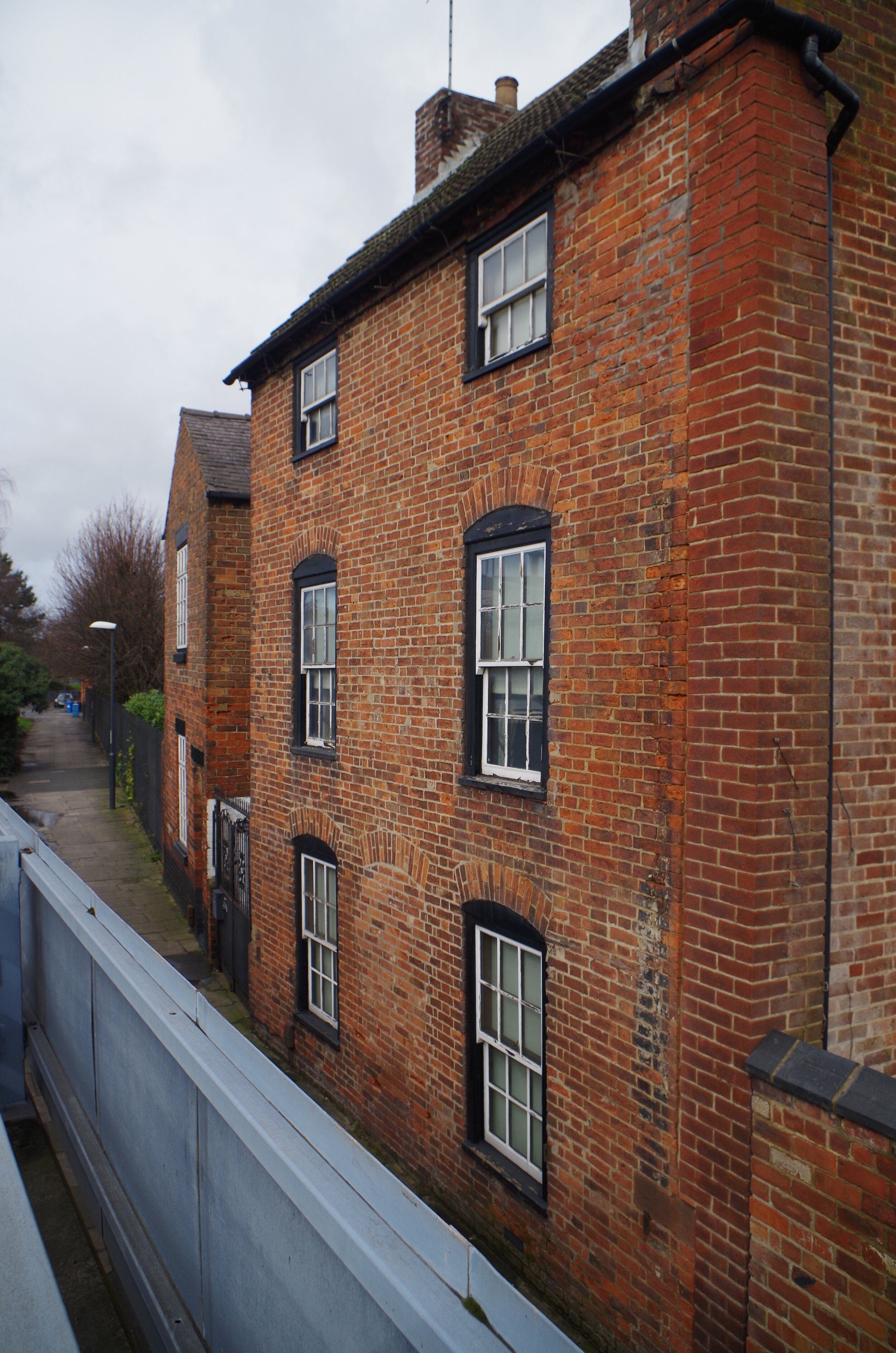


53 Nottingham Road - Front elevation, exposed sash box window and re-faced right flank wall. Images © John Robinson
53 Nottingham Road is a three storey house fronting Nottingham Road and has later outbuildings attached to the rear. It shares a narrow courtyard with 51 Nottingham Road. The main part of the building is constructed with handmade bricks and there is brick corbelling evident at the eaves and verge, both early features. A former central doorway on the Nottingham Road elevation has been blocked up. The windows on this elevation have exposed sash boxes which were generally in use from the early 18th century until c1775, but the upper sashes have “horns” which suggests that the window sashes have been replaced, probably c1850. Numbers 55, 57 and 59 Nottingham Road are all missing, presumably demolished sometime after the 1937 Ordnance Survey map was revised. As a result the right flank of the property has been re-faced, probably in the late 1930’s or 1940’s from the wirecut brickwork used for the purpose. A parapet wall has also been added to discourage water penetration. Probably, for the same reason the flank wall of the Liversage Arms has been cement rendered.
Although much altered 53 Nottingham Road bears a striking resemblance to the building to the left of the illustration of the Derby China Works in Bow, Chelsea and Derby Porcelain by William Bemrose 1898 (see above) which was evidently built for the factory owner or a works manager. This may be entirely co-incidental. If 53 Nottingham Road had been used as part of the china works previously, by the late 1820’s it was in use as a public house. In “The Directory of the County of Derby” by Stephen Glover, which was compiled over the years 1827, 8 & 9, the landlord of the Punch Bowl Public House is named as being John Robinson (no known relation!). This coincides with the Robert Bloor’s departure from the business in 1828. It is also marked as a public house on the 1899 Ordnance Survey map.
In Journal 2 published by the Derby Porcelain International Society in 1991 John Twitchett reports on the results of excavations carried out on the site of a former bakery in Alice Street. Accepting that the “the small rectangular site which was at our disposal was of course only a very small part of the whole” nevertheless his conclusion that the kiln remnants incorporated in the basement of the Liversage Arms are in fact part of the new china works as built by Kean, not part of Duesbury’s works would seem entirely reasonable. Indeed this conclusion is supported by the map extracts shown above.
The evidence indicates that the china works developed in three stages. The initial works occupied a site apparently in freehold ownership fronting Nottingham Road opposite St Mary’s Bridge and comprising seven tenaments and a house converted into workshops. Today, the sole remaining residential property, 1 Wood Street, which enjoys frontages to Nottingham Road and Wood Street, and is located at the back entrance to the College, might well have been built on the site of the initial works. Writing in 1951, Gilhespy indicates that even at that time, some of the original factory remained “A low building with an archway facing on to the Nottingham Road is now our only link with the past, all the factory buildings having disappeared these many years since.” If this is correct then the first factory must have built on land separate from what became the convent site as the convent was completely demolished. The Liversage Trust records indicate that a lease was granted to the business in 1764 to enable the factory premises to be built. We can’t be sure about the exact appearance of the buildings, but the image published by Bemrose gives an impression as to how it would have looked. There seems little doubt that this factory fronted Nottingham Road and was located within that site now occupied by the Landau Forte College playing fields. Research also confirms that the factory built by Kean and later taken over by Bloor, was within Duesbury’s Garden, and therefore within that part of the trust estate on which the Liversage Arms was built. What is the status of 51 and 53 Nottingham Road? As a bird cage walk was needed to link the two factories, it suggests that these two properties were in separate ownership - a Mr Crayne apparently in 1815 - and not part of the factory at that time. However parts of both buildings appear contemporary with the second phase of the works, post 1764. The maps are inconclusive and with Covid restrictions and work commitments it has not been possible to inspect the original plans and leases.
I would love to hear from any members of the Paget family to shed light on why Mr and Mrs Paget received the invitations (and others which will be included in later blogs). The Pagets were probably acquainted with the family of 18 year old enameller Flora Dutch who was living close by at 135 Weston Road - see “Archive Photographs” page. A Samson Selig’s death in New York is recorded for the year 1972. If any member of the Selig family would like to get in touch I would appreciate a photograph of Samson Selig should one be available.
The Missing Plaque
As for Selig’s plaque, placed first on the side and then the front of the Liversage Arms, it would be interesting to know if former publicans Andy and Jenny, or their clientele recall seeing the plaque. Indeed does anyone know of its subsequent history and current whereabouts?
John, Val and Christopher Robinson February 2020 (revised October 2021)
This Blog could not have been prepared without the kind assistance of the Liversage Trust and Derby Porcelain International Society.
https://maps.nls.uk/view/101601564
http://liversagetrust.org/about/
https://landau-forte.org.uk/2013/10/landau-forte-students-see-early-work-royal-crown-derby-co-founder-blue-plaque-unveiled-honour/
http://www.thepotteries.org/allpotters/261.htm
http://www.potteryhistories.com/page56.html
https://www.derbyporcelain.org.uk/quaker-pegg-bi-centenary
https://www.derbyporcelain.org.uk/william-duesbury-225th-anniversary
https://en.wikipedia.org/wiki/Derby_Canal
http://photo-sleuth.blogspot.com/2010/07/clarke-bloor-and-disney-families-of.html